Home |
Back to "Mountains" |
Back to "Alps" |
Deutsche Version |
print version (no menus) |
Through the Bernese Alps
Gross Grünhorn (4044 m) - Finsteraarhorn (4274 m)
Report
September 08-11, 1997
Still good weather, quite suspicious: since several weeks already. But it was not completely good, towards the weekends regularly clouds came up, bringing more or less continuous rain until Sunday evening. What to do in such a case? Of course, a week of vacation in order to profit from the good weather from Monday to Friday.
Monday, September 8, 1997
From Lake of Constance we quickly drove to Lauterbrunnen, the first shock comes at the parking garage in Lauterbrunnen. 7 Swiss Franks per day, the first days much more expensive. And that's not the only expense we have to do: At the reilway counter the clerk reacts on my request "1 1/2 times Jungfraujoch one way only" as if I would have said "Moon" instead of "Jungfraujoch". (The 1 1/2 comes from the fact that I have a half fare subscription, and Claudia doesn't.)At Kleine Scheidegg we have to wait almost an hour because the time tables are quite uncoordinated. The trip to Jungfraujoch is mostly pretty dark (long tunnel), but again and again a sort of experience. The loudspeaker announcements are now apparently in plain German (!), English, French (at least sometimes), Japanese and probably Korean. The last two groups, however, always rush up and down in closed group wagons rather than the normal "everybody's" wagons.
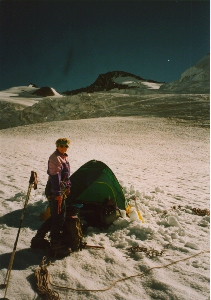
Arrived on top, we directly head towards the little tunnel leading outwards and stand on the Aletsch glacier (exactly: Jungfraufirn). It takes 35 minutes to Mönchsjoch, where we take out the rope and begin the descent following the almost endless Ewigschneefeld, until we reach our planned tent site at the base of Grünhorns at 3140 m altitude. The menu unfortunately is a little sparse this evening. Stove and fuel bottle are quickly found, but the fuel pump apparently stayed at home. So cold dishes today. Anyway, there's a beautiful sunset to look at. Has some nutrition value, too.
Tuesday, September 9, 1997
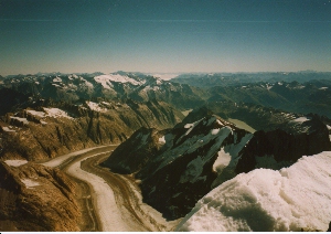
 At 4.20 we leave the tent. Completely dark, and this route appears to be rather unusual. Without a trace we have a little detour in the crevasse area, but elsewhere the way is easily found. 2 1/2 hours to the saddle at Grünegghorn; from here the route follows the rock crest which is much easier than expected: completely free of snow and mostly walking terrain. The II pitch is hardly recognizable. After an hour, the summit is reached: 4044 m. In fact, this seems to be the only 4000 m peak of the Alps from which not a single village in the valley can be seen. Around us only an arctic impression of huge glacier areas. The distant view, however, is outstanding - besides thousands of mountains also the nuclear power plants of the Swiss central region can be seen, visible by the cloud towers reaching out of the flat cloud soup around.
Descent to the camp site takes only 1 1/2 hours. Due to our somewhat unlucky food situation we go to Finsteraarhornhütte today, instead of using the tent once more. That takes another five hours, via Grünhornlücke.

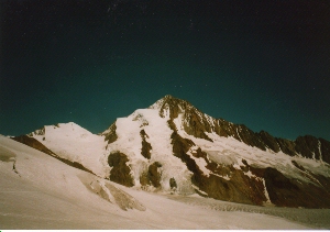
Finsteraarhorn, seen from Grünhornlücke
Wednesday, September 10, 1997
Yesterday afternoon and during the night, it was quite windy. We already were concerned because of the crest (described as rather exposed), but in the morning the wind calmed down. Departure at half past five, first an increadible scree walk up, then (now daylight is coming) without problems over the glacier to Hugisattel. The last part is very lengthy. At Hugisattel, the rock crest begins, falling down in a really spectacular way on the left side. The route, correspondingly, mostly is on the right side, and the portions directly on the crest guarantee for perfect views downwards. The conditions are optimal due to the new snow from the weekend: Mostly we can follow hard snow with easy steps, and we have to use our hands only sometimes; the steeper parts in the rock are free of snow, however. From the summit of Finsteraarhorn we enjoy an incredibly wide view to all directions. Ortler, Mont Blanc, fog in the middle lands of Switzerland, or clouds in Ticino, everything can be seen. Also the military jets that cross over the summit only some hundred meters higher.
After another two hours we are back at the hut. Having purchased enough stuff to drink (remember, we cannot cook) we set up our tent an hour further down at the base of Gemschlicke.
Thursday, September 11, 1997
In case I might have forgotten to mention: The weather still is cloudless. Today our program is the long way back to the car. First part is Gemschlicke (3335 m), a saddle five hundred meters above our tent site. The couloir to the pass purely consists of scree, recommendable only for good nerves. One has to climb faster than the scree below the feet tumbles down.From Gemschlicke we go down to a valley and again up a little to Oberaarjoch (3223 m), where the SAC hut is situated. There we can fill up our drinks. The way on does down directly over the glacier to the Oberaar reservoir. The problem Oberaar-Grimsel is quickly solved, we find someone to give us a lift in the next green light phase (the road has a one-way regulation, alternating every 30 minutes). From Grimsel we take the Post bus to Meiringen, and I fetch the car from Lauterbrunnen. Via Brünig, we soon reach our home again.
Practical hints
Times and difficulties
| route | time | remarks |
| Jungfraujoch (3454) | ||
| 0:35 | highway-like | |
| Oberes Mönchsjoch (3629) | ||
| 1:20 | almost no crevasses | |
| Ewigschneefeld (3140) | ||
| 3:30 | rock II at the crest (some meters, rest I or completely easy) | |
| Gross Grünhorn (4044) | ||
| 1:30 | Way back through the seracs mostly easy to find | |
| Ewigschneefeld (3140) | ||
| 1:00 | stay left and find the way through crevasses and scree | |
| Konkordiaplatz | ||
| 2:15 | flat and easy | |
| Grünhornlücke (3286) | ||
| 1:00 | maybe a short portion of bare ice | |
| Finsteraarhornhütte (3048) | ||
| 5:00 | rock II at the crest, rest exposed walking terrain | |
| Finsteraarhorn (4274) | ||
| 2:15 | ||
| Finsteraarhornhütte (3048) | ||
| 0:35 | make a bit a curve to the right | |
| Fieschergletscher (2870) | ||
| 2:00 | Cruel scree area. Not recommended! | |
| Gemschlicke (3335) | ||
| 1:00 | simple, small crevasses | |
| Oberaarjoch (3223) | ||
| 2:20 | simple, some crevasses | |
| Oberaarsee (2303) |
Routes
Grünhorn: first a bit of an orientation exercise along the glacier, then an easy rock crest, some meters II (mostly icy), the rest easy.Finsteraarhorn: Easy walking terrain up to Hugisattel, then rock crest, which is mostly followed on the right side. Always steep, some steps (II), especially towards the summit.
Map and guide
Guidebooks (in German):- either: SAC, "Hochtouren Berner Alpen" (CD-ROM, 2000), Routes 415 (Mönchsjochhütte), 443 (Mönch), 464 (Gross Grünhorn), 416 und 403 (Grünhornlücke), 478 (Finsteraarhorn), 404 (Gemschlicke), 512 (Oberaarjochhütte)
- or the two
- SAC, "Berner Alpen 4" (1989), Routes 22 (Mönchsjochhütte), 236 (Mönch), 325 (Gross Grünhorn), 5 (Grünhornlücke), 403 (Finsteraarhorn), 413 und 414 (Gemschlicke)
- SAC, "Berner Alpen 5, Von Grindelwald zur Grimsel" (1996), Route 12 (Oberaarjoch)
- 1:50000 LKS 264S "Jungfrau", 265S "Nufenenpass"
- 1:25000 LKS 1249 "Finsteraarhorn", 1250 "Ulrichen"
What else to remember...
Oberaar road: upwards from Grimsel 00-10, downwards from Oberaar 30-40 of every hour, between 6 and 22; during the night closed.Post bus from Grimsel to Meiringen at 14:40 (as of summer 1997).
Costs
| Lauterbrunnen-Jungfraujoch | one way Fr. 84.- |
| Grimsel-Meiringen | one way Fr. 24.- |
| Meiringen-Lauterbrunnen | one way Fr. 15.60 |
| parking garage Lauterbrunnen | Fr. 27.50 (Mo 16:00-Th 17:00) |
| and of course all the drinks in the huts and so on... |
Home |
Back to "Mountains" |
Back to "Alps" |
Deutsche Version |
© 1997, 1999 Hartmut Bielefeldt
![]() This page is confirmed to comply with the HTML 4.0 standard.
This page is confirmed to comply with the HTML 4.0 standard.
Last change August 09, 2002 by Hartmut Bielefeldt