Home |
Back to "Mountains" |
Back to "Expeditions" |
Map sketch |
Height diagram |
Practical information |
Deutsche Version |
") Slideshow |
print version (no menus) |
Expedition to Aconcagua
(6960 m)
Hartmut Bielefeldt and Claudia Bäumlerprivate trip, organized on our own
18 January - 13 February 1997
| Quick overview - mountains | |
| Cerro Aconcagua | 6960 m |
| Pico Plata | 6100 m |
Saturday/Sunday, January 18/19, 1997
Flight to MendozaAt Frankfurt airport, they're quite exact about safety once again. So we have to take off the mountain boots and put them through the x-ray control. The flight (Aerolineas Argentinas) has a stop in Rome and another one in Sao Paulo, therefore we are in Buenos Aires at 10 o'clock (13 GMT) - 18 hours after departure. The transfer to the domestic airport is quickly done, and after another two hours fligt we arrive in Mendoza. Here the temperature is 31 °C. 35 degrees more than just a day ago.
The city is situated at the western edge of the large plains, where the first mountains rise, and has 170 000 inhabitants; the whole region about 700 000. We chose the first hotel that comes along close to the center. The prices here are clearly higher than in Chile: A double room costs 35 Pesos, equals 35 US$. (The exchange rate is fixed by law, you can pay with US$ as with Pesos almost everywhere.) What is a 1-star hotel here, is considered as "Residencial" in Chile, however. Apart from that, everything in Argentina is a bit more orderly, better organized and more expensive than in Chile. For a cheap special offer diner one has to spend $6. By the way, there are even bus stops (but don't forget to give a signal, otherwise the bus won't stop anyway).
Monday, January 20, 1997
MendozaOn Monday, we first have to care for out permit. There is a special counter in the building of the Dirección de Recursos Naturales Renovables in Parque San Martín, which should be obvious even to foreigners without any Spanish knowledge. After filling a form (personal data, illness insurance and an address for the case of an accident) and paying $ 80 we are proud owners of a permission to wander around in the park for 21 days.
The next thing to do are the tickets to the starting point, Puente del Inca ($9.60 per person for 170 km). We buy some liters of fuel at the gas station (Super, all types are unleaded) for the stove and carry out the big food shopping in the supermarket, for about two and a half weeks that we have to care for our feeding. One can also book a mule for the transport to the basecamp already in Mendoza (e.g. at Aymará).
Tuesday, January 21, 1997
Mendoza - Puente del Inca - HorconesIn the morning rain with thunderstorm. The weather seems not to be as stable as we were used to in northern Chile. At the bus station short before ten o'clock rucksacks begin to pile up. Baggage and passengers are distributed to two buses in a not very obvious way. The baggage costs $1 per piece extra, and the timing of the departure can not be compared to what we experienced in Chile. However, this rather touristic bus seems to be an exception.
The bus drives through the plains with many wine and fruit plantations, then after rincón suizo (Swiss corner, where apparently many Swiss have found a new home and place to set up the Swiss flag) through a narrow valley to Potrerillos (km 57) and further to Uspallata. It is hard to believe that these are important skiing resorts, as hot and dry the scenery appears now. Puente del Inca (2716 m, km 177) is reached after 4 1/2 hours. We give the bigger baggage for the mule transport (against our expectation it is only 52 kg - so I could have taken beer cans for another eight kilograms), have only a quick look at the natural bridge Puenta del Inca and go a little bit inside the Horcones valley. The region is very windy, and only the "all around" glacier sun glasses protect the eyes a little bit from the sand. The vegetation is rather scarce, grass grows (if any) in bunches like in the Puna of the north.
At the park entrance we have to register at the rangers (Guardaparques) with our permit. As it is too far for this evening to go to Confluencia, we stay here and put up the tent on the last nicely green meadow. Probably the last one for two weeks. In late afternoon several other groups arrive. Since the wind is freshing up now, we can often see flying mattresses and other material passing by.
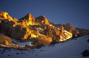
In the evening, Aconcagua shows up for the first time, having been clowd-covered for the whole afternoon. The height difference of 4000 meters is not too striking at a first glance, but it is still quite far away. The south face is quite good-looking even from the distance and only seeing the upper half.
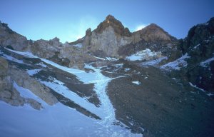
Wednesday, January 22, 1997
Horcones - Confluencia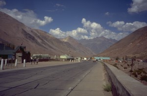
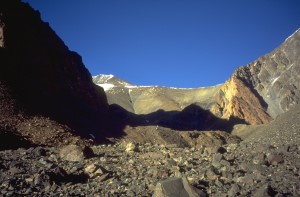
Puente del Inca
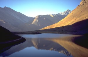
Lake Horcones, view outwards the valley
 "Lake Horcones, view outside the valley.")
Lake Horcones, view outside the valley.
The morning is calm, almost no wind. After 15 minutes we come to Lake Horcones, after another 45 minutes the river is crossed on a small suspension bridge. According to the sign, camping is allowed there, although there is no fresh water (the river is quite brown). On the following way up, several mule caravans overtake, with more or less obedient members. Three and a half hours of rather boring way end at Confluencia (3368 m), the place where the valleys from Plaza de Mulas (base camp for the normal route) and Plaza Francia (base camp for the south wall) meet. There is a small source with excellent fresh water and of course a guardaparques tent, where we are first of all welcomed friendly. Due to the sources, there are also some meadows, a very comfortable place.
The morning was completely cloudless and calm, at about two o'clock clouds came up, and around six o'clock there was a short thunderstorm with hail. Will it be like that every day here?
Thursday, January 23, 1997
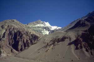
Confluencia - Plaza de MulasThe morning weather is fine again. We leave at half past seven, there's a lot to do. We had not guessed at that time, what a lot it really is. As also a big part of yesterday's stage, the trail does not follow the deeply eroded river valley but the gentle plains above, thus accumulating meter by meter to be climbed up and down. After 45 minutes the landscape opens to endless rubble plains along the curving river. After another fifteen minutes on the other river side, we reach the big stone (piedra grande) which is also indicated in the map. Another hour later we cross the only creek on our way where always (or usually) water flows. By the way, in the main river there's no water flowing yet, it is frozen until eleven o'clock. The view to Aconcagua from this side is tremendous: Huge vertical rock walls end in Cerro Piramidal (Pyramid peak), from where a bold narrow rock and ice ridge with three huge towers guides to the south summit.
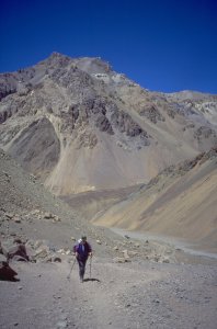
On the way to Plaza de Mulas, still about 3 hours to go
We continue, through three gravel plains, many slopes and more boring plains. The trail slowly ascends, but for an exact determination of our location the map is not sufficiently exact. When will we have made those thousand meters of height difference? In the afternoon shortly after three o'clock the ranger station at the basecamp Plaza de Mulas is reached. Of course, it was not thousand but - by all the up and down in between - 1350 meters, adding to a tough distance of more than 20 km.
Soon we found a place for the tent that should be more or less wind protected. We encounter only one more problem: The baggage was brought to the hotel. Claudia cares for clearing up our stuff, fetching water etc., and I get the baggage. Easier to say than to do: the trail is full of ups and downs, making one way half an hour; we can get two rucksacks to the tent, but the big sack has to wait until tomoorow.
Unfortunately, the pump for the stove was in there. We already had the stove (was in the first rucksack) and also the fuel (second rucksack) ... Only cold meals today. No problem, as the sausage package was damaged on the transport. So we have cold sausages with mustard.
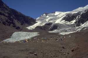
Base camp Plaza de Mulas
Friday, January 24, 1997
Plaza de Mulas (rest day) The sun reaches the camp only at about half past nine. This morning we fetch our sack at the hotel. The hotel gives a bit a "degenerate" appearance to the base camp: You just can buy there what you dont have. But you don't have to, as well as nobody has to stay overnight there. On the other hand, it is good to know a backing for case of some food miscalculation. And the hotel is like the park rangers a considerable safety factor. Just as we arrive at the hotel, an injured French mountaineer (probably a broken leg) is brought downwards on a mule. The $ 80 permit fee are well invested in infrastructure, and we can grant the hotel some turnover - buying some beer and coke cans ($ 3 each, that's what you'd pay in the Alps, too).In the afternoon we go to fetch some water again (10 min. from the tent towards the glacier) and washing away the dust of the last days (at the small lake below). Today's weather is not as good was yesterday, at noon clouds come in. In the afternoon there is a bit of sleet.
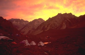
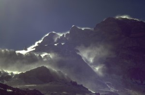
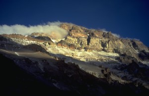
Strange colors after the passage of a bad weather front
Saturday, January 25, 1997
Plaza de Mulas - Cambio de Pendiente and backIn the night there were some digestion problems, too, probably late consequences of the exhaustion of thursday. A can of coke proves the right medicine against sugar deficiency.
As we set off with the first material transport for the first high camp at half past eight, the sky is almost cloud covered. Further up it begins to snow, and we have the pleasure to experience one of the notorious Aconcagua thunderstorms, including electric discharges suddenly felt at the head, and a strange whirr around us. Above 5000 m it snows like crazy, and therefore we don't go up to the camp Nido de Cóndores ("Condor's nest",which we, by the way, had not found in that weather). At "Cambio der Pendiente" (change of slope) at 5400 m , where the slope becomes more gentle, we put up our second tent and put in the material (food and clotes for later, when we will stay in the high camps) and wait for half an hour, until the thunderstorm would reduce a little. The descent to the base camp takes about an hour (the way up took us more than four hours). The trail itself is quite good, one always follows a broad path in a rather long and monononeous gravel slope - it is easy to keep a good walking rhythm. But what you will meet there! First, as many loners as nowhere else; second, peope carrying up everything at once (or simply can't restrict themselves) and therefore of course hardly make progress, and third many people without ski poles or only with ice axe, probably not the optimum equipment in this rubble. No wonder that such a lot of accidents happen at this mountain.
Now our sporting aim for today is done (and without any bigger condition or height problems). That's good, since for the rest of the day it snows continuously. Late in the evening the snowfall is replaced by a storm inferno, roaring the whole night through. What will our tent at Cambio de Pendiente look like?
Sunday, January 26, 1997
Plaza de Mulas - Cambio de Pendiente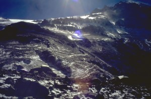
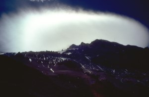
Storm and blown snow around Aconcagua in the morning.
Today we are not in a hurry and don't get up before the sun comes. No need to leave in cold and wind. The snow from yesterday mostly melts during the ascent, and again after 4 1/2 hours we arrive at our provisional campsite, a few minuted before the afternoon snowfall begins. The tent is standing peaceful and without damage, unlike the neighbouring tent. The snow drift behind the tent is very practical, because there is no fluent water up here and we have to melt everything from snow.
Today there are considerably more people on the way than yesterday, especially Americans. Besides that, yesterday's reflections about the crowd still hold: Where some run around in gym-shoes, others go with crampons and ice axe!
Monday, January 27, 1997
Cambio de Pendiente - Plaza de MulasYesterday's afternoon snowfall turned out to last the whole night again, including a pretty nice storm. Also in the morning there is no hope for improvement: Snow sweeps through the slopes from above; it makes no sense to continue to Nido de Cóndores, as we could hardly put up the tent in the storm. So we pack up the tent and deposit it with the food under a stone. Who knows, how many stormy nights will come, until we can ascend again and finally put it up further above.
We return to the base camp; the overnight stay in the high camp certainly was a profit for our acclimatization, and for sure it's the better idea to wait for the very worst weather to pass by down in the base camp.
west slope of Aconcagua, seen from Plaza de Mulas.
The summit is the leftmost bigger rock.
Tuesday, January 28, 1997
Plaza de Mulas - Cambio de Pendiente - Nido de CóndoresJust on time with sun set it stopped snowing yesterday, but in return the night became very stormy. Having re-fixed the base camp tent, we climb the - meanwhile sufficiently well-known - path to Cambio de Pendiente, spending the same time as usually. But today, the program is extended: Tent and the big sack with food and clothes that were deposited there are packed together, and we go up to Nido de Cóndores.
It turns out that also this is not the camp around the ruined hut "Antartida Argentina" indicated in the map, but the name "Nido de Cóndores" fits much better the camp here, since it is situated on a small steep rock step. The other camp is only 50 height meters away. A 15 minutes walk shows that almost everything in the map is indicated wrong, if we assume the mountain ridges to be correct. Or the altimeter makes nonsense, but why then should it indicate Plaza de Mulas correctly?
The weather today: quite reasonable (we become modest), there was no snow, and the storm eased off for three hours.
Wednesday, January 29, 1997
Nido de Cóndores - BerlinIm the "lower" Nido de Cóndores there were only eight French besides us, and they will stay for another day there for better acclimatization. Also in the "upper" camp at half past ten, nobody seems to want to take off. At last, we are the first now. But just today this honour is quite tiresome: The trace is covered with fresh snow, we have to dig a new trace through the often hip-deep snow to the next camp. The deep snow and the wind make it quite cold for our feet and hands.
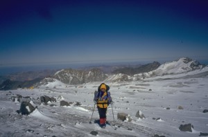
At the "upper" Nido de Cóndores
What a delight to reach the three huts of the upmost camp after only 2 3/4 hours - "Refugio Berlin" (6000 m) on the north ridge of Aconcagua. "Huts",however, is a bit exaggerated: tiny cabins, half buried in the ground, each suitable for three to four persons in the best case. If they weren't half filled with snow respectively the roof wouldn't be missing...
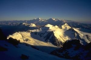
The site offers a nice close view to the next 1000 meters to be accomplished and a far outlook to Chile and to northwards to the closest mountain giant, Cerro Mercedario (6770 m) in a distance of 80 km.
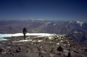
Thursday, January 30, 1997
Berlin - summit and backThis night was even more uncomfortable than the previous one: Snowfall in the tent is not new to us, but remains quite annoying. (The condensation water freezes at the inner tent and falls down lightly after every wind squall.) Adding to this comes the height with all its usual accompanying things like headache, breating shortage or also digestion problems.
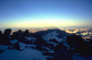
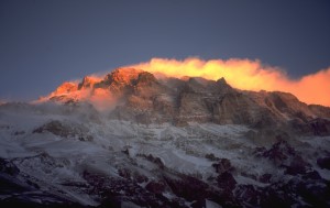
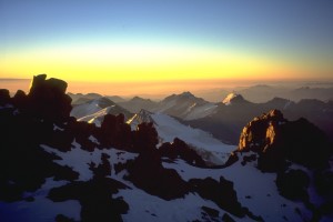
Early morning at Refugio Berlin. The triangular shadow of Aconcagua projects far into Chile.
Nevertheless, we pull ourselves together at half past seven at least for a try. The morning still is cold (-15°C) and windy. The trace first passes on the right side of the crest in the shadow, until finally the sun shows up on the ridge, giving an opportunity to defrost the feet. The trail continues through rubble and single snow fields. There are no "real" glaciers on the north side of Aconcagua except for micro size ones.
Beyond the hut "Independencia" at 6430 m (the map shows 6500 m) the huge rubble field "Gran Acarreo" that comes down from the summit towards Nido de Cóndores is crossed at its very top. Only after that, notorious "Canaleta" is entered - a 240 m high rubble gully with the summit at its end. The size of stones ranges from almost sand to about a meter, and everything is so delightfully loose. In a slope of about 35° one has to take care a bit to leave everything at its place.
Due to the wrong height of Independencia, we had expected the summit considerably earlier; now we are loosing more and more power and confidence. With almost last power we reach the Guanaco ridge connecting the higher north and lower south summit. A wonderful view deep downwards the 3000 m high south wall. An Argentine gets his proof photograph made by us and is completely beside himself with finally having arrived.
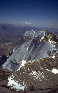
View from the main summit towards the southern summit and the Guanaco ridge. To the left, the south wall; to the right, it goes down the Canaleta.
Now only 90 height meters are missing to the main summit (6960 m); we master them in forty minutes (with the very last
power). Eight hours seem to be the usual time, and nobody creeps around here much faster than we did.
Anyhow, the weather is beautiful, as we had expeced once in ten years here after the experiences of the
last days: cloudless sky, almost calm, and temperatures allowing to sit on the top without gloves - at
almost 7000 meters!
Unfortunately we hardly know about a dozen of the mountains around us. Besides the massive
6000 m peaks in north and south our main impression is how narrow the Andes really are.
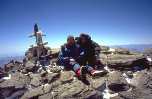
On the summit
The way back to the tent takes only 2 1/2 hours, though we walk down very slowly and carefully since we're
tired and scatter-brained due to the altitude. Still at half past four we meet people aiming at the summit, surely
having two hours to walk to the top. How would they come down again? Or, what most of them might
have thought about, being on the way alone at late evening on almost 7000 m?
Back at Refugio Berlin, after a long day
Friday, January 31, 1997
Berlin - Nido de Cóndores - Cambio de Pendiente - Plaza de MulasOf course we didn't drink by far as much as we should have done yesterday. The night becomes very thirsty, since there's no motivation to begin melting snow in the middle of the night.
At ten o'clock in the morning, everything is packed again, and 45 minutes later we are at Nido de Cóndores, where we had deposited redundant food. Amongst others, also some cans of coke, meanwhile exploded in the cold. At least, the can-opener allows us to enjoy a bit of real coke ice.
Well loaded with all our stuff we are back at the base camp after 1 1/4 hours, where non-frozen coke and beer cans await us. The rest of the afternoon is "holiday" - comfortably sitting around, completing reading all the books we brought with us and enjoying the sun. And - cynical amusement about the fact that the summit is stuck into clowds the whole noon today, therefore we got the best yesterday (well-earned, of course).
Saturday, February 1, 1997
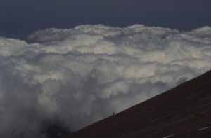
Plaza de Mulas (rest day)You can rely on it: Precisely at 9.20 the sun reaches our tent, and we can think about getting up. The nights here in the base camp are quite fresh, this morning even a water bottle inside the tent was frozen. From the southwest we see dense clouds approaching, the predicted bad weather yet comes. Aconcgua carries its characteristig big lense-shaped cloud, indicating strong altitude storms.
On Sunday there are no more mule transports free. As probably the weather for the next days won't become too comfortable, we quickly pack together everything `which is not immediately used (giving about 40 kg) and get it transported out to Puente del Inca by a mule. So we won't have to wait until Monday evening to fetch our baggage down in the village.
Today we relax a little, and tomorrow we'll go down to Confluencia or further, if things run well.
Considering the weather during the afternoon, indeed a day in the telt is the best idea. Within an hour, the weather skips from sunny to horizontal snow storm; the strong squalls sound like express trains before they arrive and throw up sand and small stone on our poor little tent.
In the evening the weather clears up again, around the summit clowds sweep with surely 150 km/h. Clearly it was a good idea to stay in the base camp.
Sunday, February 2, 1997
Plaza de Mulas - Confluencia - HorconesFarewell day from the base camp begins with cloudless skies. Quickly everything is packed, quickly we notice that the outer bags for the rucksack went down with the big rucksacks on the mule. Correspondingly uncomfortable the contruction for our small rucksacks now.
On the long way through Horcones valley we can contemplate again the beautiful brown and red color of the rocks (honestly, there is really a lot of different rocks, every mountain looks different) and we are delighted by some vegetation after about two hours. Food consists of biscuits with mayonnaise, almost the very last rests.
Besides that, it's a very far way if one makes it in one piece. After After just eight hours and 29 km we arrive at the ranger station Horcones, settle the formalities, pitch our tent there, and see to the blisters at our feet.
Monday, February 3, 1997
Horcones - Puente del Inca - MendozaThe remaining 4 km down to Puente del Inca are made more or less well. The mule company that we entrusted our baggage with, resides 2 km outside, meaning another little walk. We just have some time to visit the natural bridge Puente del Inca and the rotten baths underneath, and the bus to Mendoza already leaves at half past eleven.
The camping place in the park that was indicated by the tourist information office remains untraceable. After a long odyssey through the city, we again end up in a hotel, for $ 36 the double room. Having gotten various information and addresses for undertaking this and that in the region during the next days, we visit the restaurant that the taxi driver had recommended. A milanesa quite exactly corresponds to a Wiener schnitzel, except for the size: after 20 minutes at least I had eaten so much that thing fits onto the plate. Unnecessary to say that in the end I had to give up far from finishing it all. As far as the diner time is concerned, it is a strange impression for us to be the first customers in a restaurant at half past eight in the evening. In the morning, the Argentine people are up and about at well civilized times, but they have a longer siesta in the afternoon. Usual business hours are from 9 to 12 and 17 to 21.
Tuesday, February 4, 1997
MendozaThis morning, we went out by bus to some outskirts, merely to realize that the public bath is closed just today for cleaning and changing the water. So we only have a picnic on the lawn at some length. In Mendoza, it is mostly sunny with 28 to 30 degrees (C).
On the way back we visit the Club Andinista de Mendoza to get some inspirations what else one could do here andinistically. Like in Santiago (1994), this appears as a nice and friendly "veteran" meeting. Since we want to spend only some days in the mountains, they resommend the Cordón del Plata, which is the highest mountain chain (up to 6300 m) in Mendoza's vicinity.
Wednesday, February 5, 1997
MendozaHaving bought the bus tickets for Valle del Sol near Potrerillos, the rest of the day was a "holiday" on the plaza. For diner we had Parilla (various grilled meat); quite nice, but as usual a bit much.
Using the city buses works well, if one found out the right number (the tourist information helps a lot). For 55 Centavos one can get quite far, and meanwhile we even find back in the dark with a precision of one or two blocks.
Thursday, February 6, 1997
Mendoza - Valle del Sol (Potrerillos) - VallecitosIt's a good thing that we always allow for some extra time: The bus leaves six minutes ahead of schedule - it's already full up. The route passesg through the small villages via Luján de Cuyo to Potrerillos and leaves the international road there. After two hours we leave at the end point Valle del Sol and continue on foot. It is 3 km until we hit the road leading to the skiing area Vallecitos, and the sign there reads another 12. Unfortunately there's no bus there; even the bus to Valle del Sol runs only four times a week.
Slowly we make progress on the gravel road through a scenery with trees and grazing cows and horses. The weather is not fantastic today, cloudy and rather fresh. Just as we consider to pitch our tent and await tomorrow's weather, an Argentine family gives us lift to the skiing area (3150 m). A hint of fate - now we have to make the mountain. Half an hour above, we put up the tent on a meadow, and finally we have enough water from the creek.
Friday, February 7, 1997
Vallecitos - SaltoIn sunny weather (now we even can see where we are) we climb through the Pampa, full of birds, butterflies, and some horses. Later we reach the barren regions furher up, mostly morain scree, without water along the trail. After six hours we reach the glacier edge near a waterfall (Salto), where we settle. During the day, more and more clouds came up. Curious how it will be tomorrow when we'll go for the summit of Cerro Plata.
Saturday, February 8, 1997
Salto - Pico Plata and backThe night was partly very windy, and holds during the morning (and as we will see, the whole day). The sky, however, is cloudless. Getting up at seven, at six it's still sooo dark. At eight o'clock we leave and soon have the wind against us.
The trail leads back into the high valley, which is taken up by the glacier on the one side. Huge rubble fields and a characteristic gap at Cerro Muela give evidence of a rock avalanche not too far ago. Many of the glaciers are buried under rubble, making them hardly recognizable. After an hour the trail leaves the valley ground and climbs up to a small pass on the left side, then following the ridge and in the very end of the valley turning right again in slightly more even terrain, avoiding the very steep scree slopes underneath.
A high plain opens (5500 m), and we can see that Pico Vallecitos appearing so unfriendly from below, can easily be reached on a trail through the slopes of the other side. Nobody here would climb in those loose rock walls voluntarily.
Our trail follows the right flank of Pico Plata and Cerro Plata. Meanwhile we have already made more than 1000 meters of height difference, and the headwind makes us slow and tired. It's already half past three, the main summit still far away. So we turn left, directly climbing up the slope, reaching Pico Plata (
Cordón del Plata
From Cordón del Plata to the east, we see only the clouds over the Pampa.
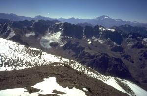 View from Pico Plata to Aconcagua.
Sunday, February 9, 1997
Salto - Vallecitos - Potrerillos - MendozaAfter yesterday's action we can sleep a little longer today, now it's the others' turn for Plata. Two hours down to Vallecito, where we encounter the problem of the day: how to get to Mendoza? Fortunately a family with a car takes us along, otherwise we had to walk down all those curves. They only want to go to the creek, but today is Sunday, and all comfortable places are occupied by people having a picnic. So we have to walk only from the turn-off to Valle del Sol, "only" four kilometers to the main road, where after one hour waiting time somebody takes us to Porterillos. From there there is a bus that really goes at four o'clock. But it is rather full up, even more after Potrerillos. The only unused space if the bus driver's lap. Nevertheless: better an uncomfortable bus ride than a comfortable walk, since Mendoza is 50 km away.
Diner today is bife chorizo - a huge portion of meat, which is quickly polished off without any problem.
Monday, February 10, 1997
MendozaBack in town, we are too lazy again to do any visiting tours. And there is not too much to do for a day except for bodegas (wineries). Another day in the park.
Dienstag, February 11, 1997
MendozaToday we finally found a public bath with water-filled pool. First time in an open-air pool in February, even if the water was rather cold (apparently freshly filled this morning). Probably we will enjoy the sunburn from the lawn for quite some time.
For diner this time we shared one pizza, being enough, too. Even for $ 13 including drinks, one can easily eat one's fill.
Evening contemplation of the traffic: Compared to elsewhere quite disciplined, but certain technical details like indicators or headlights only enjoy a vanishing attention. Drivers' command of their vehicles gives rise to the assumption that in this country mainly firm will enables to conduct a car rather than taking one's driving test.
Wednesday, February 12, 1997
flight backMendoza airport is reached easily and well in time. Not much going on here, the building apparently was dimensioned for bigger tasks two years ago.
After the flight to Buenos Aires, we enjoy a more or less well organized bus transfer to Ezeiza airport. The intercontinental flight is full up (fortunately only until Sao Paulo). Very impressive the flight over the huge emptiness of Sahara desert.
Remarks about the heights of the mountains of Cordón del Plata
The mountains heights in Cordón del Plata which we found on the basic map which was available at the time of our trip have to be corrected downwards. Corrections are:- Plata (6300 m) is only 5966 m
- Pico Plata (6100 m) is only 5827 m
Sources for the corrected heights:
(C) Hartmut Bielefeldt 1997 - 2017
Home |
Back to "Mountains" |
Back to "Expeditions" |
Map sketch |
Height diagram |
Practical information |
Deutsche Version |
Slideshow |
print version (no menus) |
![]() This page is confirmed to comply with the HTML 4.0 standard.
This page is confirmed to comply with the HTML 4.0 standard.
Last updated: July 10,1997 by Hartmut Bielefeldt
Minor corrections October 10, 2017